This time, it isn’t excessive rainfall, but swelling Gulf waters posing a threat to Sarasota.
By Ramon Lopez
Original Air Date: September 25, 2024
Host: Hurricane Helene is passing by us in the gulf late tonight and tomorrow at a greater distance than Hurricane Debbie in August, but that doesn’t mean at all that we’re off the hook. The main concern continues to be flooding, but this time it’s the storm surge we should watch. Ramon Lopez reports.
Lopez: Coastal evacuations are underway in Sarasota County and Manatee County in the face of soon-to-be Hurricane Helene, which is rapidly intensifying over the extremely warm waters of the Gulf of Mexico. Of greatest concern to our area is storm surge versus wind and flooding rains. The exceptionally large and powerful storm is on track to make landfall late Thursday on Florida’s Gulf Coast, possibly in the Big Bend region. Earlier forecasts had rainfall from the system potentially dumping a total of 4 to 6 inches of rain in the region through Saturday. But if Helene tracks farther to the east, the area could see higher totals of up to 7 inches.
But Tuesday afternoon, Sarasota County Emergency Management Chief Sandra Tapfumaneyi provided an updated assessment.
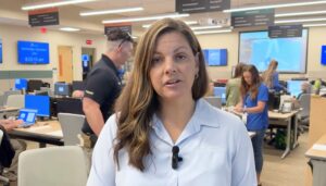
Sandra Tapfumaneyi
Sandra Tapfumaneyi: We are still in the recovery from Hurricane Debbie, and now we’re faced with another storm that’s impacting our community. Tropical Storm Helene has formed across the western Caribbean and is going to start making its way up the Gulf of Mexico. The wind field for this storm is very large. The National Hurricane Center has shared that it’s within the 90th percentile of wind field size for hurricanes. So while we are not in the direct path of the storm, we will still receive impacts here in Sarasota County. Currently, Sarasota County is under a number of watches. We’re under a hurricane watch, a storm surge watch, and a flood watch. The main timeframe for impacts will begin late Wednesday night into early Thursday and last throughout much of the day Thursday.
We do anticipate the storm will exit and make its way out up into the Big Bend area. Due to the large size of the storm, we are forecasted to receive 4 to 7 feet of storm surge. And if we receive the higher end of this estimate, the storm surge could travel a mile or two inland.
Also, as the storm continues to develop, the track can still shift. So, we may still receive more storm surge than that 4 to 7 feet. We’re not anticipating hurricane strength winds at this time. Rather, we should see strong tropical storm force winds. According to the National Weather Service, the rainfall is expected to be between 3–6 inches. But it could be up to 10 inches in some areas. And by comparison with our tropical storm Debbie, we received 17 inches. So the rainfall for this storm is anticipated to be fewer or less than we had for Debbie. But the storm surge is an increased amount.
RL: Sarasota County Sheriff Kurt Hoffman warned the public about dangerous floodwater. He said high-water trucks and flat-bottom airboats, used to perform hundreds of water rescues in the wake of Hurricane Debby, are again at the ready.
Sandra Tapfumaneyi said Hurricane Debby and Hurricane Helene are different storms.
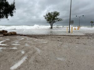
Flooding at Venice, Thursday morning.
ST: Sure. Well, the storm is very different this time than for Debbie. So, the information and the forecasting that we have from the National Hurricane Center is showing much more significant impacts, especially with storm surge. So because of that, and because we have this high prediction for storm surge along our coastline, we’re issuing these evacuations ahead of time.
RL: Local public schools are closed so they can be used as evacuation centers. The Level A evacuations involve coastal homes and manufactured home communities. Level A includes all of Longboat Key and Siesta Key, as well as areas along many rivers and creeks. An evacuation order is also be in place for the following neighborhoods: Fort Creek in Englewood, Curry Creek and Hatchett Creek in Venice.
The county’s stormwater system was unable to handle Debby’s deluge, which made flooding so drastic in some areas last month. Sarasota County Public Works Director Spencer Anderson says preparations are ongoing for Hurricane Helene.
Spencer Anderson: Currently we are doing preparations around the county for the predicted rainfall and storm surge that will likely produce some kind of flooding, and then more in the coastal areas. But we are looking at all of our stormwater infrastructure to clear our hotspots of existing debris, make sure they’re open for flow, in addition to all of our stormwater pump stations out on St. Armands, Siesta Key Beach, and along Phillippi Creek. We’re also dropping, or have dropped, water levels in celery fields and upstream in Calpin Slough. Those have not really changed since the previous storm came through. We’ve kept all of those wide open. So they drain to the minimum levels before the storm comes through. We’re also pre-positioning some pumps and traffic control devices in order to address flooding in some areas that may or may not be expected and to try to mitigate some adverse flooding in areas that we can control.
RL: This is Ramon Lopez for WSLR News.
WSLR News aims to keep the local community informed with our 1/2 hour local news show, quarterly newspaper and social media feeds. The local news broadcast airs on Wednesdays and Fridays at 6pm.