Storm surge warnings, shelters, and possible water service troubles.
By Johannes Werner
Original Air Date: October 9, 2024
Host: Milton has the potential to be one of the most destructive hurricanes on record for west-central Florida, according to the National Hurricane Center, and the worst for the Tampa area in 100 years. It is an extremely dangerous Category 5 hurricane and our area is under a Hurricane Warning, Storm Surge Warning, and Flood Watch. Milton will make landfall along the coast late Wednesday night. Hurricane conditions are expected beginning late Wednesday through early Thursday.
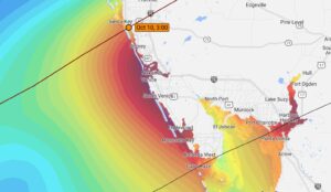
NOAA’s CERA assumes landfall at Siesta Key. The worst surge will be from Siesta South to Charlotte Harbor.
Johannes Werner: But life-threatening storm surges will begin earlier today. Current predictions are for between 10 and 15 feet along the coast of Manatee and Sarasota County – which will be catastrophic in Flood Zone A, and tough on Zone B.
NOOA’s Coastal Emergency Risk Assessment (CERA), in its latest advisory, assumes the eye of the hurricane will make landfall on Siesta Key, and expects the worst surge to occur along the shore from Siesta Key south to Venice.
Storm surge is not just a coastal threat. Water will travel inland up rivers, canals and creeks.
Here is how Sarasota Fire Chief David Rathburn puts it:
David Rathburn: Please do not compare this to a previous storm. Sarasota County has not had a direct hit from a major hurricane in the history of this place. If you need something to reference, go look at hurricane Ian in Fort Myers Beach back in 2022, and that’s what you could use to explain what could happen to the coastline, inland in Sarasota County. Resources of our partners are a little bit stretched thin. There’s a number of federal urban search-and-rescue teams that are still deployed to North Carolina and still in the aftermath of Hurricane Helene, they are freeing some of those assets. We may have a delay of being able to get urban search-and-rescue teams on the barrier islands. I cannot emphasize enough, you need to evacuate now.
If you are in evacuation level A, B, or C, officials in both Sarasota and Manatee Counties are urging you to get out now and head to either a family or friend’s home in a higher level or an evacuation center.
Evacuation centers at Fruitville Elementary and Gulf Gate Elementary are at capacity and no longer options for evacuation. The next closest evacuation center is Philippi Shores Elementary, located at 4747 S. Tamiami Trail.
Taylor Ranch Elementary School is also no longer an option for evacuation. The next closest evacuation center is at Heron Creek Middle School, located at 6501 W Price Boulevard in North Port.
There is a full list of open evacuation centers at scgov.net.
Booker High is one of the largest shelters in the area. According to Sarasota County, that school is 55% full, with 9 occupants and 63 pets, but there’s space for many more. Sarah Hernandez is sheltering at Booker. She says administrators are urging current occupants to take not more than their assigned space in classrooms, and workers are currently preparing hallways, marking spaces for future occupants. She started her account with a particular kind of evacuees.
Sarah Hernandez: Currently, there are 68 dogs, 46 cats, one bunny, six gerbils, five birds and two fishes. People are taking care of their pets, bring them into the shelter, trying to have the whole family be safe. We were waiting in line when they opened yesterday. That was a very calm, smooth process, filling in forms, etc. It went fairly smoothly. They took us to the pet room first, and once we settled our pets, we were taken to our room where we humans would be staying, and then they fed us. So we had lunch and dinner here, and it was a fairly smooth process. They would call us by groups of people. First the elderly or folks with mobility problems, where, in some instances, they had the food taken to the rooms, and then they had families with children coming in next for their meal, and then single men and women. Today, however, there’s a big rush of people coming in for shelter. So then they’re in a big, much bigger rush. They sent a general announcement asking people to be more conscientious about the amount of space they’re taking in each of the classrooms, and explain that they’re anticipating 1,800 people to come to the shelter.
Ashkan Fakhrtabatabaie teaches music at New College. He and his wife Audrey Mund evacuated because they are renting a home in flood zone B. They experienced a public evacuation center for the first time.
Ashkan Fakhrtabatabaie: Yeah, the first day, actually, there were not a lot of people here, so we were assigned into a room. I think they were conscious about who they were putting together. I think since we signed up as a family, they put us in a room with other families, and that was nice. So we did have an air mattress. We brought that with us, and we set it up and we had a little corner for ourselves, or we could put our backpacks, and other things that we brought with us. But then, so the first time, it was like three families in there. But then second day, which is today, a lot of people started coming over, and it’s getting crowded. At this point now I think there are about 30 people in the classroom.
Mund is a violinist at the Roanoke Symphonic Orchestra. She actually brought her violin with her.
Audrey Mund: It’s really secure here. I’m not worried about the weather as much, and it’s kind of hard to sleep. But, you know, I feel a lot better knowing that this is a safe place to be doing.
JW: You’re a violinist. What did you decide to do with your violin?
AM: I brought it with me because I don’t want anything to happen to it. And no matter where I go, I always have it with me, like even if I went on a plane, I would have it with me. It would be my carry on. So it’s kind of no-brainer for me to bring that with me.
JW: Have you played it in the shelter?
AM: I haven’t, and I don’t know if I will. Some people might enjoy it, but others maybe not. I think a lot of people on the outside of the situation, they think that it’s all, like, very nerve wracking, and it is like people are nervous and everything, but everyone is also in good humor. It’s just been really refreshing, and everyone, for the most part, is really nice and helping each other out, which is great to see.
JW: Once the storm is over, you will see a Sarasota you have never seen. Expect power, Internet, possibly water outages. Sarasota County Public Utilities Director Brooke Bailey:
Brooke Bailey: From a water side, if you do have the time, fill up your bathtub. We do have generators staged throughout the county for all of our pump stations. So if we do lose power at those, they will switch over to generator power. However, with saying that, you know, the ground is very saturated, we could have some trees that fall. They could lift up some of our pipes and our infrastructure could break, which could be a reduction in pressure or loss of water from a lift station side, from the wastewater side. We have close to 800 lift stations. If we get that 15 foot of storm surge, about 200 of those will be impacted. So we have already designated crews and started thinking about how we’re going to go out and evaluate those post storm.
Reporting from Sarasota for WSLR News, this is Johannes Werner.
WSLR News aims to keep the local community informed with our 1/2 hour local news show, quarterly newspaper and social media feeds. The local news broadcast airs on Wednesdays and Fridays at 6pm.