Size of Helene and wind strength make for historic surge along Gulf Coast.
By Florence Fahringer
Original Air Date: September 27, 2024
Host: Storm surge was the No. 1 hazard of Hurricane Helene here in our area. WSLR News reporter Florence Fahringer puts the focus on the phenomenon, talking to victims and experts.
Florence Fahringer: Last night, Helene made landfall in the crook of Florida’s Big Bend, crashing into the panhandle as a powerful category four hurricane before barrelling north towards Atlanta and the Appalachians. Before landfall, the hurricane cruised its way through the Gulf of Mexico, spending most of Thursday just over a hundred miles off of Sarasota’s shores. Siesta Key resident Lourdes Ramirez was expecting to feel some reverberations, and prepared accordingly, piling sandbags to keep the water out; What she wasn’t

Lourdes Ramirez
expecting was her house being underwater by the morning.
Lourdes Ramirez: I’m one-story. I don’t have a second story. I would say [water rose to] three feet into the house, and all the rooms. I think the garage got the most, but the rest of the house got a lot of water, and I had two cars parked there and both of them are totally lost.
We left when it started to rise. We stayed next door. My neighbor has a patio, she’s got two stories. We just went there and we’re still there now. When I looked around with a flashlight — because of course we lost power — around in front of this particular home, which is two stories, but it was flooded all the way up to the staircase. And next door also flooded, across the street flooded.
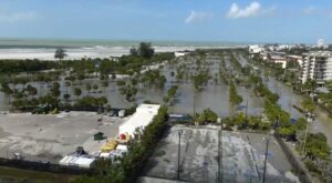
Drone footage of Siesta Key the morning of Sep. 27
It was just … we believe that … the neighbors and I are talking, because some of the condos also suffered like Jamaica Royale, Dolphin Bay, and we think the Gulf of Mexico just reached over to the bay. It just covered Siesta Key. So it was pretty devastating and shocking, because I’ve lived here 25 years, and I’ve never, ever seen such devastation with flooding on Siesta Key.
FF: Back on the mainland, the severity of the storm surge was less pronounced; Karen Stack, resident of the bayside Uplands neighborhood, says more homes flooded during Debby than Helene.
Karen Stack: I’m grateful that we did not flood. The street in front of our house is eight feet above sea level, and the field absorbed all of that surge. Uplands Preserve protected, it did what it’s supposed to do, which is keep us from experiencing flooding up to our houses, and it did that.
FF: That being said, she did note that development projects on the Uplands Preserve exacerbated the effects of the storm surge.
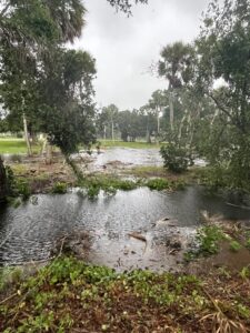
Flooding in the Uplands, per Karen Stack
KS: And it was interesting to be able to compare what happened on the field in front of my house versus what happened on the elevated field that was repurposed by New College.
FF: For both Stack and Ramirez, this storm surge was the most severe they had ever experienced during their decades-long residency of the Uplands and Siesta Key. So what gives? Why did Helene have such an unprecedented impact on Sarasota, even though its eyewall never came within a hundred miles of the area? Ric Kearbey, senior scientist at the Climate Adaptation Center, has an idea of the culprit behind Helene’s outsized impact.
Ric Kearbey: We see a direct correlation here, especially with the warmer Gulf temperatures. We’ve seen record warm water in the Atlantic and the Gulf this year. So, even heading into hurricane season, we had concerns of how that could fuel storms that do develop, temperatures of 85 to 90 degrees. We hear often people say it’s like bath water, it truly is.
So you got really warm water in the Gulf and also a warm atmosphere, so it holds more moisture for these storms to develop as well. And another thing it does, and a lot of people, it’s becoming unfortunately a household term, but rapid intensification. These storms are going to happen, growing by 35 or more miles per hour in a short time. So people go to bed often and it’s a tropical storm or a low Cat One and all of a sudden it’s Cat Three. So, rapid intensification is something that used to be somewhat rare, definitely less than 10% of storms. And that number seems to have at least tripled. It is almost becoming commonplace now, where we see this happening with storms.
So that’s a real problem is, these storms develop. And so as they rapidly intensify, they have more wind. That means more wind blowing on shore when a storm like Helene pushes through, because even though the storm is 100 miles or more off the coast, you see those strong winds, you see higher sea levels to begin with as well.
And so it all just adds up to bigger storm surges. Helene was bigger than 90% of storms that have ever developed in this area. So the wind field was huge. So that’s why they felt this as far south as, it flooded in Fort Myers and all up the coast. So you had a huge storm system with that big wind field and that moved completely up the coast.
So you still have to look at the size of the storm, the strength of the wind, how deep is that pressure, how strong is the inner core of that storm, there are a lot of ingredients to look at, but one thing you can take away is that storms are different now because the water is warmer, so they have the ability to strengthen, sea level is higher, so you’re starting at a higher point. It doesn’t mean every storm is going to produce record surges like we saw with Helene by any means, but you definitely have to watch it much more closely. And what a similar storm would have done 25, 30 years ago is going to bring more surge, more frequent surges, potentially stronger ones as well.
FF: Kearbey says that while it looks like this hurricane season will produce fewer storms than initially projected, peak season isn’t over yet.
RK: We as well, for all the reasons I mentioned, expected more named storms, I think, than we saw. I don’t think the amount of storms probably will hold to that forecast. The amount of major hurricanes still has a chance. You have to think that peak hurricane season, peak of the whole thing, and remember this, this runs through June 1st through the end of November, But the peak part is around mid September through mid October. So we’re not even into the beginning of October yet. Models are already showing some potential developments in the next week to 10 days, pushing up the Caribbean again. So perhaps there’s another one we have to watch. But yeah, long way to go, so don’t let your guard down.
FF: This is Florence Fahringer, reporting for WSLR News.
WSLR News aims to keep the local community informed with our 1/2 hour local news show, quarterly newspaper and social media feeds. The local news broadcast airs on Wednesdays and Fridays at 6pm.