To look at the big picture, we talk to a meteorologist and resilience advocate.
By Florence Fahringer
Original Air Date: June 12, 2024
Host: Sarasota and Manatee counties just experienced a record-breaking May; weather for the past few weeks has been unusually hot and severely dry. That dry spell ended yesterday with another record-breaking event, as a torrent of rainfall inundated parts of Sarasota in a series of flash floods. This much rain in such a short period has never been recorded in Sarasota before. Florence Fahringer talked to Bob Bunting of the Climate Adaption Center to get a better idea of what the hell just happened.
[frogs croaking]
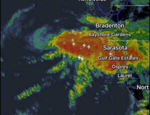
Almost a named storm: Tropical system Invert L90
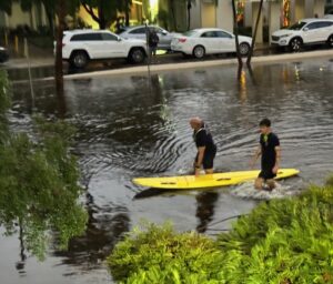
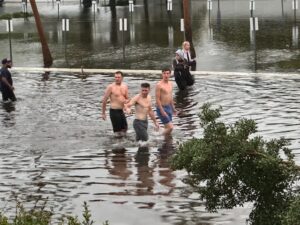
Florence Fahringer: The morning frog croaks which follow a nighttime storm haven’t been heard in Sarasota for many weeks; but yesterday, the Suncoast sky finally let loose its belated May rains across the city, and it did so all in one night. A number of Sarasotans found themselves stuck in flash floods in their commute home last night, and a number of city districts found themselves swamped by the sudden rainstorm.
The Sarasota Fire Department responded to 282 total calls for service yesterday, 100 more calls than their daily average. Forty-seven of those were flood-related, 43 of which were about flooded cars and the remainder downed wires. Several neighborhoods reported blackouts, and FPL and city crews were seen working to fix problems this morning.
Our news team talked to Bob Bunting to get a better idea of what just happened. Bunting is a meteorologist and Founder of the Climate Adaptation Center, a Sarasota-based organization which aims to “bridge the gap between state of the art scientific research and public sector understanding of our changing climate.” Addressing climatic extremes in order of occurrence, he sets the scene with the drought which immediately preceded the flood.
Bob Bunting: We had 25 inches less rain in the last year than normal. Up until yesterday, normally, we would have had two feet of rain more than the two feet we had in May. This was the warmest May in Sarasota history, by a lot. And the 99 degree high temperature we had on May 31 was the record highest temperature recorded in May, ever. And just a week later, we’re having another record event.
FF: That “other record” Bunting alludes to is the amount of rain which fell last night, something he described as a thousand-year event.

Bob Bunting
BB: Well, you know, when you have 1000-year event, it’s always worse than you expected. [laughs] To be quite honest with you, this is what we expect. Well, we had 3.55 inches in one hour. So that was the record. But as far as how much rain we had, you know, it varied across the metro area. For instance, Lido, St. Armand Circle had 10 inches. The airport had something along the line of seven, seven-plus inches, and it ranged from, you know, seven to 10 inches throughout the city of Sarasota.
FF: With the amount of rain and the wind speeds reached, Bunting said the sudden storm last night was nearly the first named system of the season.
BB: We were right on the borderline of a named system last night, because the Sarasota airport recorded 40 mile an hour winds, and tropical storm winds start at 39.
FF: The first named system of the season just kind of appeared right off the coast of Sarasota?
St. Armands Circle. Photo: Dale Anderson
BB: Correct, correct. It went right over Sarasota. It was an unnamed storm, because had it been out in the Gulf a little longer and had a little more time to form … It was a meso scale, a very small-scale storm, you know, in the sense of hurricanes, but sometimes we have really, really small ones, and this one was wrapping up, and it was right on the edge of being a named storm. So as you know, we’re splitting hairs here, but for all practical purposes, we had a tropical storm and it did not have a name.
FF: So what’s the cause of the local climate’s record-breaking performance? As it turns out, extremes beget extremes, and a warmer world is one big extreme.
BB: We’re operating in a lot of ways like it’s 1990. But the climate has changed radically since then. For example, between 2010 and 2023 ,we’ve had five inches of sea level rise in Sarasota. So that means whenever we have a storm event, we have a lot less buffer for things like storm surge. But right now, we’re in a very serious situation because the ground is saturated. And, you know, we haven’t had rain, essentially, heavy rains in a whole year, so a lot of debris probably washed into our storm drainage systems and what have you. And things are saturated now, so it won’t take a lot to create flash flooding over the next four or five days.
FF: In this pattern of dry season being way drier, wet season being way wetter, you’re expecting that to continue in the years to come?
BB: Well, I think we’ll see those things more frequently than we’re used to. And it’s the signature of a warming climate. It’s one of the signatures. So the answer is yes.
FF: Eventually, we touched on the elephant in the room: if this is just the first rainstorm of hurricane season, what should Sarasota expect from what’s projected to be one of the more active seasons in recent memory?
BB: We’re entering a hurricane season, where the Climate Adaptation Center issued in April its hurricane forecast, which is in the annual hurricane forecast that we do every year. Last year, we issued a perfect forecast, and this year we forecast 24 named storms, 12 hurricanes, which, by the way, is 80% more than normal, and six major hurricanes, which is double the normal.
FF: Bunting emphasized that while there’s no cure-all solution, there are certainly things local governments and communities could be doing to mitigate disaster in the hurricane season to come.
St. Armands Circle. Photo: Dale Anderson
BB: There’s a lot of things that we have to do in these flooding areas, and we have to ask ourselves whether we want to do further development in low-lying areas, because with hurricanes and tropical events now, and the time of a warming climate produce a lot more water. And you know, our systems that we have now are not really made to handle these things, so for every dollar we spend on the front end, we can prevent about $20 worth of damage on the back end. Preemption is always a better choice.
FF: As for the week to come, Bunting has a forecast: rain, rain, and more rain.
BB: We’re in a very wet situation, and we’ve gone from a … so think about this: We had an epic 1000-year flood with Hurricane Ian less than two years ago. That was followed by an epic 25 inch below normal drought for the last year or so, followed by this. We’re in a very soggy tropical system that looks like it’ll persist for the next week. So we’ll have periods of showers and thunderstorms, and some of those are going to be extremely heavy.
FF: Bunting’s organization, the Climate Adaptation Center, uses the Saint Augustine Lighthouse as its symbol. It hopes to play a similar role to the lighthouse, helping to navigate Floridians through the rough weather. To find out more about the organization, how to stay updated on Florida’s warming climate, and how to get involved, you can visit the website at theclimateadaptationcenter.org, all one word.
This is Florence Fahringer, reporting for WSLR News.
WSLR News aims to keep the local community informed with our 1/2 hour local news show, quarterly newspaper and social media feeds. The local news broadcast airs on Wednesdays and Fridays at 6pm.