At a briefing, Sarasota County’s new emergency chief gives pointers about what you need to heed, and what’s new.
By Johannes Werner
Original Air Date: May 22, 2024
Host: On June 1, hurricane season officially begins. Here are a few pointers from the new emergency management chief in Sarasota County. Her name is Sandra Tapfumaneyi, and she came from Lee County where she led the response to Hurricane Ian. She also comes with a b.a. from Eckerd College and a masters in International Peace and Conflict Resolution from American University in Washington. Our news team was at the Sarasota County Emergency Operations Center for a briefing yesterday.
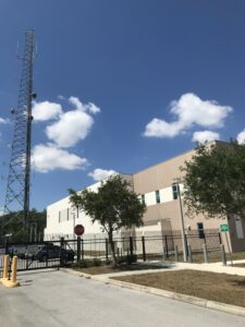
The Sarasota County Emergency Operations Center
Johannes Werner: At the east end of Bahia Vista, just before I-75, there’s a three-story, bunker-like building with a tall antenna tower. That’s the county’s command center when disaster strikes. Which, in all likelihood, is a hurricane here.
That’s where Sarasota County staged a hurricane-season briefing yesterday for local news media.
Sarasota’s disaster-responder-in-chief gave a few pointers.

Tapfumaneyi
First of all, know your ABC’s – the evacuation level of the place you live in. Also: Have a plan where to go, including your pets. Practical measures: Gas up your vehicle before long lines form and charge your electric car. Move your vehicles to higher ground, if flooding is ahead. Disaster kit: Drinking water, batteries, solar-powered devices, your medication, most important documents – you know the routine. Know what to take with you when you evacuate.
There are 12 public shelters – most of them schools – in Sarasota County. They do not require prior registration, but they may be full if you arrive last-minute. They also welcome your pets. Most of the shelters do have a separate room for pets in cages.
Sandra Tapfumaneyi: Also, we are encouraging people to keep evacuation centers as a last resort. It should really be utilized if you have no other place to go. You’ll be much more comfortable if you’ve evacuated with a friend or family outside of the evacuation zone. It’s also very important that people don’t necessarily go hundreds of miles to evacuate, as long as you get outside of the evacuation area. That’s going to be better than trying to get on the road and competing with traffic and fuel along the way. So this is why it’s a great time of year to figure out who do you know that lives outside of the evacuation level areas and make that plan now. But if you do need an evacuation center, they will be open. They’re all pet friendly. We ask that you bring supplies for your pets so that you can take care of them while they’re there. Also, for residents that have qualified medical needs, we will have a Medically Dependent program that will be running with evacuation centers managed by the Department of Health. We ask that they pre-register for that program so that we can help plan for getting a space for them in those evacuation centers. So you can do that by going to our website to get the application at scgov.net or by calling 311.
JW: While public shelters do provide food and water, as well as entertaining human company, be aware you must bring everything else.
Bigger picture: Don’t trust what you think you know. Yeah, Sarasota may not have seen a major hurricane strike in a generation. But that could be over any day. Tapfumaneyi:
ST: We have a tendency as humans to base decisions on what we have seen in the past. And that’s a very dangerous philosophy to have when we’re talking about hurricanes, because every storm is different. And the impacts that you might face with a future storm might look completely different than anything Sarasota, Southwest Florida has seen in the past. So we are encouraging people to not make evacuation decisions or protective measure decisions based on storms from the past and what has happened in your neighborhood, but to listen when the Emergency Operations Center is getting information as storms approach.
JW: More pointers from Tapfumaneyi: You might miss “the cone” when watching forecasts this year. The National Hurricane Center is moving away from its traditional approach of likelihood of wind speed and trying a new approach focusing on likelihood of danger and damage.
ST: The National Hurricane Center is making adjustments to its forecast, and they are going to be pushing out an experimental product about mid-August, and this year’s cone is going to be focused more on hazards. What we’ve seen in recent storms is that people really want to stay focused on where the storm is going, which is very important. But the borders of that cone only show one part of the story. We’re going to be pushing hazards and information on hazards, and you’re going to be hearing that a lot from our public communications team and from emergency management.
JW: Also, be aware Watches and Warnings, particularly when local emergency managers upgrade a Hurricane Watch to a Warning.
ST: So if you’re under a watch or warning, especially for a hurricane, it’s important for residents to understand that a watch is when hurricane conditions are possible within the next 48 hours, and a warning is when those conditions are expected. So when we move from a watch to a warning, that’s really a time that you need to pay attention and make sure that all of your protective actions are in place.
JW: Sarasota County offers an alert system via phone, text or email. You can register at alertsarasotacounty.com.
Finally, wind speeds.
ST: Also important: The National Weather Service issues an excessive wind warning. So the excessive wind warning comes if we reach winds that are a category 3 – 111 miles per hour or greater – and if within the next hour, those excessive winds may be encountered here and expected within the area. That’s when we definitely need people to be inside the innermost parts of their home, or wherever they’re sheltering at that point in time.
JW: Reporting from Sarasota, this has been Johannes Werner for WSLR News.
For more information, go to https://www.scgov.net/government/emergency-services/hurricane-preparedness-6291
WSLR News aims to keep the local community informed with our 1/2 hour local news show, quarterly newspaper and social media feeds. The local news broadcast airs on Wednesdays and Fridays at 6pm.